Des Plaines River Trail Conditions 2010, DPRT Flooding

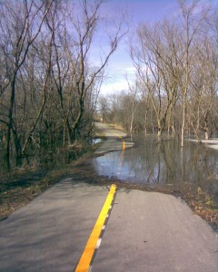
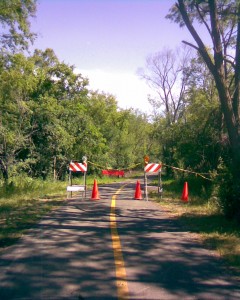
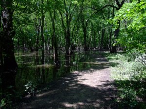
Wright Woods trail Flooding

Wright Woods about 3/4ths of the way around the outer loop

Well with the rivers being as high as they are right now, it’s no surprise that parts of the Des Plaines River Trail (DPRT) is flooded and some of the underpasses closed.

I have not been on the DPRT myself this year, but I just received an update from a friend who has just been on the trail. I also do not have the conditions for the entire trail but for the part of the trail around Route 60 and Wright Woods. 

My friend told me “The trail was mostly good with only a few puddles and damp spots but then there were a couple spots where it was completely flooded out.” 

Apparently the Route 60 underpass is closed and my friend just missed a good photo of the bike rider in the shot below as he was riding through the flooded underpass. There are cutoffs and ways to get around the flooded underpasses if you choose.

See the Des Plaines River Trail Flood Photos here. (I’ve moved the photos from the blog to a page for better formatting).

If anyone has any additional updates on the DPRT conditions, please feel free to add a comment to this post.

Photo copyright 2010. Compliments of Dale Kiffel.

Illinois Bike Trail Flooding.

I just took a ride on the Paul Douglas Bike Trail and found that it has flooded once again on the west side along Huntington/Freeman road. This page has some photos and updates if you are interested in the latest conditions on this trail (also see this blog post). 

I also just took a trip to WIU in Macomb and I noticed a LOT OF FLOODING the whole way. Basically, the lakes, rivers and streams in a lot of Illinois are very high or flooding right now.

I know from past experience that if my local trail (the Paul Douglas trail) is flooded, then I’m sure there is some flooding on the Des Plaines River Trail(DPRT) too. The DPRT is very close to the Des Plaines river and has highway underpasses that flood pretty often when the river is high.

The Fox River Trail (FRT) is mostly up a little higher and away from the river enough to where I have not run into flooding problems on that trail before myself.

I’ll add more updates as I ride these trails, but if any of you out there reading this blog have been out to any bike trails with flooding (or by the rivers that aren’t flooded), Id really appreciate a comment to this post for updates.

Thanks, Rob.

Fox River Bike Trail Conditions 2010

I just checked out the construction on the FRT in South Elgin and am starting this blog post for the Fox River Trail conditions for 2010 even though I have not ridden the rest of the trail yet this year. 

FRT Construction

FRT Construction in South Elgin


I knew that the South Elgin construction was a major event on the trail so I wanted to check that out before planning any log trips on the FRT. 

I ended up taking quite a few photos and had quite a bit of additional information so I created a new page with the updates and photos (see the link below). 

There is quite a bit of information at the page/link below and in the 2009 FRT Bike Trail Conditions in this blog so I’m not going to rewrite all of that here but I do want to have this post available for additional updates on the Fox River Trail conditions. 

I’ll be updating post this as I ride more of the trail this year but if anyone else has updates on the FRT conditions, please feel free to add comments. 

For the Stearns Road Bridge construction information and photos see:  The Fox River Trail South Elgin Construction 

Thanks, Rob.

Algonquin Road / Paul Douglas Bike Trail Conditions – 2010

I just did my first ride of the season on the Algonquin Road / Paul Douglas Bike Trail today! It was an excellent day for a ride and I’ll be updating my Bike Trail condition reports for this year, as usual.

 There is no construction on the trail but there are a few wet areas (where you’ll need to slow down to avoid a mud streak on your back (unless you have fenders or something) and unfortunately, there is a little flooding again this year just north of  Lakewood (on the west side of Paul Douglas woods).

The flooding is not nearly as bad as it was last year and it is completely possible to ride through it though. I’d say that the deepest part is only 3 inches and that is only for a few feet in distance. It’s not much worse than riding through a deep puddle but you will need to slow down to get through it.

Flooding along the Paul Douglas Trail

Flooding along the Paul Douglas Trail

I took a few photos with my phone. My phone is old and the photos are not very good but I think that they are good enough for you to get the idea.

Another thing that I noticed is that the house that was at the top of the hill, just east of the Grassy Ridge Meadow park is now gone! I guess they just leveled it. I don’t know who owned the property and house or if that was Forest Preserve land, but the hose is no longer there.

And one final note. I did see a couple of my deer buddies along the trail again so I guess they made it through the winter OK!

Des Plaines River Trail Video is Up.

I just completed editing and uploading the Des Plaines River Trail video!

I took this video last week when I rode the trail from Half Day (Route 22) to the northern end of the trail (mile 0) at Van Patten Woods just before the Wisconsin border. My trip was 58 miles (with a few extra short trips).

The DPR Trail was clear the whole way and there were no detours or flooding, which does happen on this trail occasionally. All of the underpasses were open.

I really like this trail but unfortunately I ended up with 45 minutes of original video! I edited the video down to 18.5 minutes but it is still my longest bike trail video and I like to try and keep them shorter than that. I considered breaking this up into 2 videos but decided to keep it as one for now.

I still haven’t had a chance to contact the indie musicians for new music so I am still recycling my original instrumental music for this video (for now anyway).

I think that this video came out pretty good but, as I mentioned, it is pretty long. There are a lot of major scenes on this 27 mile trip and I just didn’t want to chop it down too much.

I think that a lot of people do not ride this trail because it is crushed stone and not paved. I have ridden this trail many times with the skinny tires of my road bike and do not find that to be much of a problem but there are places where you need to slow down, of course.

OK, enough yakin. Here’s a link to the new Des Plaines River Trail Video!

You’ll need some time to watch this one (if you plan to watch the whole thing) and it may take a few seconds to load, but I hope you like it.

Fox River Bike Trail Conditions – 2009

We just did a 64 mile bike ride on the northern end of the Fox River Trail(FRT), from Dundee to Algonquin and including of the McHenry County Prairie Trail (PT) from Algonquin to Genoa City Wisconsin, yesterday.

This post is for the conditions on the Fox River Trail. There is no construction, flooding, detours or washouts in the northern part of  the FRT (from Dundee north) at this time.

7/30/09 – Update

I rode the remaining southern part of the Fox River Trail (from Oswego to Dundee) yesterday. There is no flooding at this time but there are a number of detours and pending construction plans that you should be aware of.

The main construction and detours that you should be aware of as you go from south to north are:

Bridge Construction in Aurora – There is some major highway work being done on a bridge that the trail passes under near Aurora. The trail is open and the construction is fenced off but it looks like they could close it temporarily if necessary.

Trail Closed and Bridge Out, South Elgin – The stone bridge that goes over the river and under
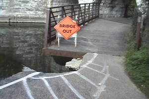
Stone Bridge Closed

Stone Bridge Closed

 the train tracks around South Elgin has a big section missing and the trail before and after the bridge is closed. I went through the closed section to explore and was able to get by (very carefully) but this could change at any time and I can’t recommend going through this because it could be dangerous. There may be an easy detour around this but I didn’t take the detour so I can’t say.

Detours in St. Charles – There are some detours as you go through St. Charles but they are marked and not that much more difficult than going through St. Charles without the detours.

Detours in Elgin – There are some detours as you go through Elgin but this is pretty typical and the detours are marked.

Trail Closures for Stearns Road Bridge Project – There are large signs just north of the long bridges in south Elgin that say that they are building a new highway bridge over the Fox River and that parts of the trail will be closed from the end of July 2009 through December 2010 (all of next summer!). There may be a temporary detour but nothing specific was mentioned.
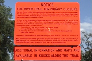
Stearns Road Bridge Construction

Stearns Road Bridge Construction

The signs refer the www.stearnsroad.com website which I visited and it gives a lot of information on the roads but nothing specific about the bike trail. There was also an email address posted and I have sent an email to this address requesting more information about the “temporary detour”. I will post an update here if/when I receive anything on this. The website said “The Fox River bike trail is set to be closed from South Elgin to the John J. Duerr Forest Preserve beginning 8/3/2009.”

I don’t get out to this trail all that often so if anyone has updates please feel free to add comments to this post.

McHenry County Prairie Trail Conditions – 2009

We just did a 64 mile bike ride on the northern end of the Fox River Trail (FRT), starting in Dundee, and including of the McHenry County Prairie Trail (PT) starting in Algonquin and ending in Genoa City Wisconsin, yesterday.

This post is for the conditions on the Prairie Trail. There’s no construction, detours or  other problems on this trail at this time. The trail is mostly crushed stone except for the northern end which becomes more of a dirt road and is pretty rugged.

There are some indentations from horse hooves on part of the trail which makes it a little bit rougher than usual but that is not a long section and it is not all that bad.

FYI: We also branched off on to the Hebron Trail at the northern end of the PT but we only rode that trail for about a mile. The first mile is very loose gravel and not nice to ride on at all.

Busse Woods Trail Conditions – 2009

Well I just rode the Busse Woods trail today and the entire trail is open and there is no construction or detours.

I rode the main “red” trail, the “black” trail (the northern branch that goes out to Golf Road), and the “purple” trail that branches out to Alexian Hospital and the Elk Grove Community Bridge (Over Route 53/355).

FYI: I also brought my camcorder and video taped this trail so I will be adding this one to the growing list of bike trail videos very soon. This particular post is dedicated to the condition of the trail so I will add a new post once the video has been edited and uploaded to the website.

For more information on this trail and the trail photos see The Busse Woods Bike Trail. It was a beautiful day when I did the original photos of this trail so there are quite a few nice photos of this trail and I also took the exact same route for the bike trail video (starting at the Elk Heard).

Algonquin Road / Paul Douglas Bike Trail Conditions – 2009

SEE COMMENTS TO THIS POST FOR THE LATEST UPDATES.

I just rode the Algonquin Road and Paul Douglas Bike Trails today (7/15) and there is construction going on in many places in the “new” trail sections (around Paul Douglas forest preserve and just past Penny Road through the Crabtree preserve).

I guess that the new trail is still under warranty 🙂 (It’s been less than a year since it’s been open).

As of today, there are about 5 patches of construction between Ela Road and the Grassy Ridge Meadow forest preserve entrance. The area that used to flood (along Freeman/Huntington Roads just north of  Lakewood) is closed and there are a few more patches on the western end of the trail starting at Penny Road.

Trail Closed north or Lakewood on Huntington/Freeman

Trail Closed north of Lakewood along Huntington/Freeman

I didn’t have my camera but got a shot of the construction area with my phone camera.

I think this may actually be a very good thing especially if they fix the area that floods just north of Lakewood.

I did walk around the trail closed signs to see what they were doing in that area and the path is completely removed (to gravel) but I did not see any new bridges or drainage pipes under the trail. I am hoping that they have just not gotten to that yet.

It is still possible to ride the entire trail but the construction patches slow you down although you can easily walk around or sometimes ride around the areas being worked on.

You must detour around the area along Hunington/Freeman just north of Lakewood (this is an easy detour of about 1/10th of a mile on Hunington/Freeman, which is fairly wide and there is not that much traffic in that area.

If you would like more information or to see the photos or video of this trail, see The Algonquin Road Trail.

I am very close to this trail so I will ride it occasionally and post updates when I have them.

Palatine Trail and Deer Grove Trail Conditions – 2009

I just rode the Palatine Bike Trail and Deer Grove Bike Trail 2 days ago (on 7/6/9).

Both trails are in good condition and there is no construction, floods, or detours.

I also video taped and recorded both trails. I hope to have the videos of these trails up tomorrow (right after the Green Bay and Robert McClory bike trail videos that I am “rendering” while writing this update.