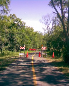
McHenry County Prairie Trail Conditions – 2009

We just did a 64 mile bike ride on the northern end of the Fox River Trail (FRT), starting in Dundee, and including of the McHenry County Prairie Trail (PT) starting in Algonquin and ending in Genoa City Wisconsin, yesterday.

This post is for the conditions on the Prairie Trail. There’s no construction, detours or  other problems on this trail at this time. The trail is mostly crushed stone except for the northern end which becomes more of a dirt road and is pretty rugged.

There are some indentations from horse hooves on part of the trail which makes it a little bit rougher than usual but that is not a long section and it is not all that bad.

FYI: We also branched off on to the Hebron Trail at the northern end of the PT but we only rode that trail for about a mile. The first mile is very loose gravel and not nice to ride on at all.

Busse Woods Bike Trail Video

Alright, The Busse Woods Bike Trail Video is complete and has been uploaded to the About-Bicycles website!

I just rode and recorded this trail two days ago. Fortunately, I have had the time to put the video together already and I actually think that this is the best bike trail video that I have done so far (well, I would hope that I would be getting better as I do more).

It was a pretty nice day when I recorded the video (a little cloudy but still very acceptable) and I think I have gotten better at the video transitions between scenes. Actually, I think I will back track and redo the transitions that I did in some of the earlier videos because each transition is unique and the transition fx should fit and be used sparingly.

The other thing that worked out very well with this video is the sound track. I don’t have the time or resources to hire a band or orchestra and sound engineer to synchronize the sound track to the movie so I just have to use what I have available. In this case, it is my instrumental recordings (done on a 4 track recorder quite a few years ago).

Well, I added the songs/sound tracks that I had in the order that I liked for each video scene and somehow it ended up being very well synchronized with the video!

If you watch the entire video the music does sync up very well with the video. Unfortunately, based on the Google Analytics statistics that I use for my website I see (based on the average time on each video page) that most people skip through the videos and do not watch them all the way through.

Well, it is asking a lot to have people that are surfin the web to stop and watch an entire 15 minute video but if some of you do, and if you are really into cool bike trails, I think you will enjoy this one. Even if you just check out a few minutes here and there, I still think this one came out pretty well.

I guess this post has gotten a little long and a little technical but I think that some of you may want the inside scoop behind the videos 🙂

OK, here ya go… Here’s the Busse Wood Bike Trail Video!

Busse Woods Trail Conditions – 2009

Well I just rode the Busse Woods trail today and the entire trail is open and there is no construction or detours.

I rode the main “red” trail, the “black” trail (the northern branch that goes out to Golf Road), and the “purple” trail that branches out to Alexian Hospital and the Elk Grove Community Bridge (Over Route 53/355).

FYI: I also brought my camcorder and video taped this trail so I will be adding this one to the growing list of bike trail videos very soon. This particular post is dedicated to the condition of the trail so I will add a new post once the video has been edited and uploaded to the website.

For more information on this trail and the trail photos see The Busse Woods Bike Trail. It was a beautiful day when I did the original photos of this trail so there are quite a few nice photos of this trail and I also took the exact same route for the bike trail video (starting at the Elk Heard).

Algonquin Road / Paul Douglas Bike Trail Conditions – 2009

SEE COMMENTS TO THIS POST FOR THE LATEST UPDATES.

I just rode the Algonquin Road and Paul Douglas Bike Trails today (7/15) and there is construction going on in many places in the “new” trail sections (around Paul Douglas forest preserve and just past Penny Road through the Crabtree preserve).

I guess that the new trail is still under warranty 🙂 (It’s been less than a year since it’s been open).

As of today, there are about 5 patches of construction between Ela Road and the Grassy Ridge Meadow forest preserve entrance. The area that used to flood (along Freeman/Huntington Roads just north of  Lakewood) is closed and there are a few more patches on the western end of the trail starting at Penny Road.

Trail Closed north or Lakewood on Huntington/Freeman

Trail Closed north of Lakewood along Huntington/Freeman

I didn’t have my camera but got a shot of the construction area with my phone camera.

I think this may actually be a very good thing especially if they fix the area that floods just north of Lakewood.

I did walk around the trail closed signs to see what they were doing in that area and the path is completely removed (to gravel) but I did not see any new bridges or drainage pipes under the trail. I am hoping that they have just not gotten to that yet.

It is still possible to ride the entire trail but the construction patches slow you down although you can easily walk around or sometimes ride around the areas being worked on.

You must detour around the area along Hunington/Freeman just north of Lakewood (this is an easy detour of about 1/10th of a mile on Hunington/Freeman, which is fairly wide and there is not that much traffic in that area.

If you would like more information or to see the photos or video of this trail, see The Algonquin Road Trail.

I am very close to this trail so I will ride it occasionally and post updates when I have them.

Bike Trail Info from Satellite and Aerial Images

Since we are right in the middle of prime bike riding season, I wanted to pass along some helpful information about checking out bike trails for those of you who may not have already discovered these methods.

Many of us bike trail riders already know some good resources on the internet or are pretty good at finding basic bike trail information (like trail distances, surfaces, trail heads, maps, etc.) through the general search engines.

Once you have found a trail that you would like to ride and ready to go to the next level, I have found that checking out the trail with the satellite and aerial options that are available through sites like Mapquest or Trails.com or with Google Earth can be very helpful (I believe that there may even be more sites with these options now, but these are the ones that I am most familiar with).

There is no shortage of websites that have the basic bike trail information for popular trails (although many of the smaller or out of the way trails are often overlooked) and this website has some good first hand trail information, photos and now even videos of bike trails in the Chicagoland area  (as well as some in Wisconsin and other places) and you will probably want to check out this info for new trails that you are considering or new sections or branches of trails that you may have already been on.

If you are planning a fairly long bike trail ride or really want to check into the surrounding terrian then the satellite images really come in handy. I prefer the sites that add street names when you zoom in to the area that you are interested in.

Printed bike trail maps are great and are a good starting point and it’s nice to keep them with you on a long ride or on a ride in an unfamiliar area. I have found it best to scan a copy of my favorite map and just keep the 8×10 copy with me on my bike because then I don’t have to fold my map to the right area and wear out my map on every ride.

So the printed maps are definately beneficial but there is just way too much information that is not available on the printed maps that can be very obvious with the satellite/aerial images. It takes a little time to research, but once you have zeroed in on the trail that you are planning to ride and have zoomed in to the levels that you like, this option will give you a lot of great information before (or after) exploring new bike trails.

Well, I hope you have found this little update helpful. Enjoy those new trails and your rides!

Palatine Trail and Deer Grove Bike Trail Video

Alright, I have another bike trail video posted to the site! This one is the Palatine Trail and Deer Grove Trail videos.

I have been on a roll with the bike trail videos. I recorded the last 2 videos while the weather was nice and went into “the lab” to download, edit, format and update the website with the new videos on the rainy days.

I actually recorded this one before the Green Bay/McClory video but I did the editing on the Green Bay video first (since it was a longer trip and trail(s)).

The Palatine and Deer Grove trails connect at Dundee Road and I often ride them together so I combined the video for the 2 trails together. The distance that I rode on the trails was approximately 13 miles.

Deer Grove also has a lot of “mountain” or unpaved trails but I just stuck to the main paved trail for this video, although I did video tape the very beginning of one of the unpaved trails.

Well the bike trail video format should be familiar to you now (for those of you that have seen the other videos on this site). So here’s a link to the new bike trail video.

The Palatine and Deer Grove Bike Trail Video

For a new twist on my old saying: Enjoy the Virtual Ride!

Green Bay and Robert McClory Bike Trail Video

As I promised a few blog posts back I have completed and uploaded the Green Bay Trail and Robert McClory Bike Trail Videos!

The videos are really new since I just took them on 7/7/9. I had a little time to put the video together, render the video flash file and upload it to the website so I completed this one fairly quickly.

You can now find the new bike trail video from either of the bike trail pages on this site or directly at this link: Green Bay and Robert McClory Bike Trail Video.

The video tour starts in Wilmette and goes to the Great Lakes Metra Station (just north of Lake Bluff).

I used much of the same original instrumental music background as I did on the last video (The Algonquin Road Bike Trail Video) since I own the copyrights on the songs and it is just way easier that way. I used a slightly different selection and order of the songs.

Now that I have a few bike trail videos out there, I have added a video icon to the bike trail pages for the trails that have videos and have also added a completely new Bike Trail Videos Page so there are a number of different ways to find and access the bike trail videos on this website.

As for a little background on the videos in general, I am trying to put together a good number of videos of the bike trails in the Chicagoland area to have all in one location and in a consistent format.

As for the Green Bay and Robert McClory bike trail videos specifically, I’ll let you in on a little “behind the scenes scoop” on some technical difficulties that I had with the video (even though it is embarrassing).

I missed most of the first 9 minutes of my trip (north of Wilmette to somewhere in Winnetka). Somehow I got out of sync with the camcorder. It makes a beep every time that you press the record/standby button but I wasn’t looking in the viewfinder to read what was saying. So every time I thought that I was recording it was in standby mode and every time I thought that it was in standby mode it was recording!!!

Arrrgh!I lost all of the stuff that I wanted to record and recorded my legs pedaling mostly!!! I got back in sync somewhere in Winnetka and was OK after that. I managed to salvage some of that video mostly via some still pictures in the video.

So now when you see that section, you will know that it was not some creative artistic inspiration but a technical corretion :-(.

I hope you enjoy the video.

Des Plaines River Trail (DPRT) Conditions 2009

SEE COMMENTS TO THIS POST FOR THE LATEST UPDATES

Well, I just talked to a friend about the latest condition of the Des Plaines River Trail (DPRT) and it is not in very good condition at the moment.  a lot of the crushed stone has been washed away and there are muddy sections and places that have been patched with loose gravel or sand.

As of yesterday (7/5/9) I’ve been told that this is the worst condition that the trail has been in for quite a few years.

Here’s a direct quote on the trail conditions from my email on 7/5/9:

“Did 34 mi on the dprt.  The path was Ok most of the time.  There were a few bad areas, like the 1st major bridge where you’re going downhill into an area that was patched with the larger stone gravel which could possibly be dangerous.  Then near the underpass in Libertyville as you start to go downhill, there is a 6″ drop off from the trail into this new stuff which is mostly sand.  If I wasn’t going downhill I wouldn’t have made it.  I had to walk it on the way back.  Lots of lines of erosion which had been filled with the large crappy gravel which you can’t ride on, or sand which you can’t ride on either”.

New Bike Trail Conditions Categories

I just got an update on the Des Plaines River Trail conditions and decided to create a new blog category for bike trail conditions for the trails that my friends, the website visitors and I have been on recently so you can select the new bike trail conditions category and find the latest conditions (that have been posted here) on each of the trails that we have ridden recently.

The blog category will be Bike Trail Conditions and I’ll be creating one for each trail that we have been on by season. I’ll probably include the dates of the rides but the blog entry dates should give you a good idea about the dates of the  updates too.

I will then add comments to the conditions of each bike trail as I receive updates or ride the trails myself.

Well, I’ll be starting the bike trail condition blog category updates next. I hope this is helpful to you all.