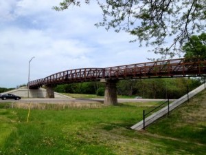
New Bridge on West End of Busse Woods Trail

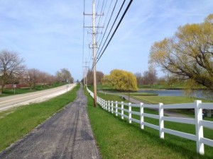
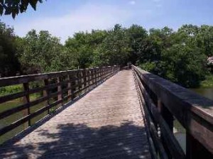
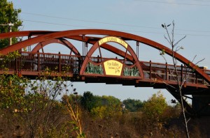
Finally! We have a New Bridge over Higgins Road (Route 72) on the west end of the Busse Woods Trail (BWT). I first noticed the bridge ~ from Higgins Road below ~ this past December (2013) but I had not ridden the trail yet this year.

New Busse Woods Bridge

New Bridge Over Higgins Road for Busse Woods Trail

I also know that the bridge was not in place in August of 2013 when I took the BWT to the last Tour of Elk Grove ~ which, by the way, sadly probably was the actual “last” Tour of Elk Grove which I will cover in a future blog post soon.

The New Bridge on the west end of the red trail is a huge improvement in the Busse Woods Trail system. I always hated the busy road crossing at Higgins Road and the expressway entrance and exit ramps. There were lights, painted pedestrian crossings  and crossing signals but this was still a fast and busy and dangerous intersection where you needed to cross at least 6 lanes of traffic. On top of that, you would almost always have to stop and wait for the signals to cross which would break up the momentum of your ride.

Well, now you can ride the entire Busse Woods Red Trail loop, on both sides of Higgins Road, almost non-stop (on a good day anyway). There are actually 2 bridges over Higgins Road now. The bridge on the east end of the Red Trail, by Arlington Heights Road, has been there for many years now. Having both bridges now is just a great improvement to this trail system.

So this past week, I finally had a chance to ride the Busse Woods Trail with the new bridge ~ and it was excellent, of course. Being May, the newly planted grass, had not fully come in and was still mostly brown but I did manage to photograph the new bridge and update the Busse Woods Trail pages on this website and include a New Photo Page with photos of the new bridge.

You can find the original Busse Woods Trail pages here. The original photo pages were from fall of 2005 so there are a few photos of how the old trail section and crossing looked before the new bridge.

Then I have included photos of the New Busse Woods Bridge here.

I have also included my GPS ride data and Map of the Red Trail here (on the Garmin Connect site) now that I have my GPS bike computer (Garmin Edge 800) and can capture my ride data.

Finally, if you prefer a video, you can see my original video of the entire Busse Woods Trail (prior to the new bridge) here on YouTube. The video was done with an old camcorder so the quality is not great and the audio was done with some now obsolete recording equipment so it’s quality is also not great BUT on the other hand it does include the ENTIRE TRAIL and the sound track is original :-).

The video is 14 minutes and 45 seconds and the old Higgins Road crossing is brief and at the 6 minute marker.

Coming Soon… I will be posting an update on the Tour of Elk Grove status soon and I just returned from a trip to Wisconsin where I had a chance to ride the Lacrosse River and Great River Trails. Of course I have photos and will post an entire update as soon as it is completed so stop back soon…

Millennium Trail Connection to North Shore Bike Path

I have ridden most parts of the Millennium Trail (MT) and the North Shore Bike Path (NSBP) in the past but had never ridden the far eastern part of the MT or the far western part of the NSBP and since both parts of these trails run parallel to Route 176 I was curious if the 2 trails connected to each other. Millennium Trail East near Route 176

First, I researched this on Google Maps, which is a great way to check out trail connections or new trails and new bike routes. You can start out with Map View and zoom in to where you are planning your ride then check out the actual terrain with Satellite View or zoom in further for the Street View if it is available. Google does not have all of the smaller trails listed in their mapped areas but they do have most of the longer trails.

Anyway, I found that the 2 trails do NOT connect directly to each other but you can take the MT east to Midlothian Road then ride alongside Hawley Street on the sidewalks (or on the street if you don’t mind riding in traffic) to get to the NSBP at Carmel Catholic HS.

You can get a good idea about the routes on Google Maps but I wanted to see what it was like first hand so I headed out to the Country Bumpkin Nursery ~ at Gilmer Road and 176, which is where I wanted to start my trip east ~ to check it out this trail connection.

My experience on this ride was that the eastern part of the MT was not all that great but it was paved and straight so you could go fairly fast if you like, the trip through Mundelein on the sidewalks pretty much sucked and the western part of the NSBP was actually pretty nice.

I also did a short ride on the Des Plaines River Trail (DPRT) when I got to it from the NSBP. The DPRT is actually one of my favorite trails in the area.

So in addition to this blog post, I wrote up the details on this ride along with photos and the GPS Maps of the rides on the following pages: Millennium Trail Connection to North Shore Bike Path and the NSBP West End Photo Page.

So many trails… so little time…

McHenry County Prairie Trail Detour Update

I just received the following update on the McHenry County Prairie Trail construction and detour from the McHenry County Conservation District .

Bridge on Prairie Trail

Bridge over Fox River on Prairie Trail

A detour is in place and signs are posted through the Algonquin Bypass Area.  (From the ramp in Algonquin you head NE on Harrison and take a left on Washington; the signs then guide you left along Route 31/Main St. back to the trail to head north.)

I haven’t been on this trail yet this year myself but the detour would be just after you cross the Fox River heading north into Algonquin.

Just an fyi, for those of you who may not be that familiar with this trail, the McHenry County Prairie Trail is the trail that connects to the northern end of the Fox River Trail in Algonquin and continues north to Genoa City, Wisconsin.

You can actually ride these 2 trails from Oswego, Illinois to Genoa City, Wisconsin! There are a few breaks in the trail ~ like going through Aurora ~ and there is construction occasionally ~ as described above ~ but you can ride these trails all day if you want to.

I have actually ridden the entire distance of both of these trails but on multiple rides. I did do a 100 mile ride one time taking the Fox River Trail north from Geneva, Il then connecting to and riding the Prairie Trail north to Genoa City, Wisconsin then back to Geneva. Most parts of both of these trails are paved too.

Anyway, the update above is the latest info that I have on the Prairie Trail.

Wisconsin Bike Trails, Gazelle, Divvy Bikes and a Beautiful Day

I got a little behind on my blog posts so I decided to cover a variety of topics that I really wanted to talk about in this post.

First off, I went up to Sparta and Cashton Wisconsin last week to visit my family and I also packed up my bike to try to hit a few bike trails while I was there. I was most interested in riding the 2 trails that connect to the Elroy-Sparta Trail to the west ~ the Lacrosse River Trail and the Great River Trail,

This turned out to be a total bust for 2 reasons. First it was cold and snowed while I was there but I also wanted to mention that, after I got there, I called Speed’s Bike Shop, which is right on the Elroy-Sparta trail to get the trail conditions and discovered that these crushed stone bike trails do not open until some time in May. The trails are still soft and moist and they try to keep them in better condition by keeping bikes off of them so early in the year. So the lesson that I learned here was that if you are planning a bike trip in Wisconsin in early spring you should call first.


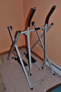
The Gazelle: The next topic seemed appropriate for the cold, snowy weather on my Wisconsin trip but a little out of season based on the weather that we had yesterday (Easter Sunday). Since I have ridden and reviewed so many exercise bikes for this site and have also used and reviewed a number of treadmills on my new treadmilll website,    www.treadmillereviews.com I am always interested in the various aerobic fitness equipment that I am able to check out. Gazelle workout machine

It turns out that my brother got a Gazelle workout machine recently and I saw it parked in the corner and decided to check it out.

These workout machines are very economical ~ they usually only cost about $130, new, for a basic model ~ and you can get a pretty good aerobic workout on them.

I only did about a 10 minute workout and, since I had my bike computer and heart-rate transmitter, I checked out my HR and saw that I got it up to about 80% of my max HR in that 10 min workout. What I noticed the next day is that my calves were sore so it seems like this machine gives your calves a pretty good workout.

The main downside to this machine, like almost any indoor fitness equipment, is the repetitive motion and that it can get pretty boring if you do not have anything to keep you entertained. My brother had some music playing on his PC so that helped and I usually like to have a tv around to help with the boredom factor too.

Although most indoor aerobic fitness equipment has pretty repetitive motion, I think that I like the motion of exercise bikes, treadmills and elliptical trainers a little better than the motion of the Gazelle (which seems a little like cross country skiing). The advantage that the Gazelle has is that it is so economical and it does not take up much space when it is setup for use and even less space when folded up and moved out of the way.


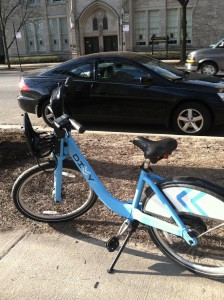
Divvy Bike in Chicago

Divvy Bike in Chicago (and our car in the background)

Divvy Bikes in Chicago: My final topic for today has to do with those light blue Divvy bikes that you can rent in Chicago. As I mentioned earlier in this post it was a Beautiful Day yesterday here in Chicagoland and my wife was in the city, rented a Divvy bike (for a 24 hour period) and took quite a few trips around the city for just $7!!! 

The Divvy bike rental system is really designed to be used for commuting and quick trips around the city but if you know how to work the system (as my wife discovered) they can also be used for some economical touring and site seeing.

If you do not have an annual membership then the minimum time that you can get a pass for is 24 hours. This costs $7.00 as I mentioned above. The problem is that you must return the bike to one of the many docking stations within 1/2 hour or pay an additional fee ($2 for 60 min, $6 for 90 min). The additional fee is not even all that bad but the costs could add up if you kept the bike out of the docking stations for too long.

Chicago Lakefront Trail

Chicago Lakefront Trail downtown

The 30 minute time limit for the docking stations can be a hassle but since there are so many docking stations it is possible to check in to a docking station after 30 minutes then just check the same bike back out again and move on to the next station.

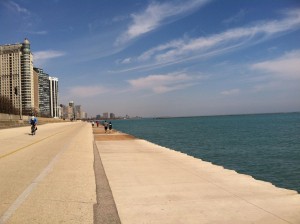
My wife even took a little ride on the popular Chicago Lakefront Trail. I am not sure, however, if you would be able to cover a lot of ground on this trail using a Divvy bike.

Overall, the Divvy Bike System seems like it can be a pretty cool option to have when you are downtown and if it meets your needs at the time.

Well, that’s it for my blog topics for today. Sorry for the blog backup and long combination topic post. I’ll try to keep these posts coming more regularly ~ especially now that we are fully in outdoor riding season!

First Rides, Trail Signals and Trail Conditions

Yep, riding season has arrived here in Chicagoland! I normally get my first rides of the season in a little sooner than I did this year but I finally got my first ride of the year  last week. I was still doing my walking and running routine when the weather first started improving this year.

I usually consider riding season to start and stop pretty close to daylight savings time but this year I think there was still snow on the trails when we started daylight savings time. Anyway, it really felt good to get back in the saddle and out on the trails again.

One thing that I noticed as being very helpful this year as a walker/runner and bike rider is to not only signal your intentions ~ like letting other people on the trail know that you are coming up behind them and passing ~ but also to acknowledge that you heard the rider that is about to pass you.

For example: When a rider comes up behind me ~ when I am walking or jogging ~ and either says the old standard “on your left” or has a bell or horn or something (I prefer and have a bell myself) is to just give a thumbs up, as you continue walking or whatever, or even to just say OK or something similar just to let them know that you heard them.

I find this really helpful as a rider because I know that the person or people ahead of me heard me. I usually thank them for that simple gesture and I have found other people usually thank me when I acknowledge their passing intentions too.

Of course there are always the riders that are completely silent and stealthy and speed up behind you and scare the sh** out of you when they are right next to you and passing but then there will always be all kinds of riders out there. I think a little common sense and courtesy goes a long way to make the trails safer and more fun for everyone.

Paul Douglas Woods Trail

Paul Douglas Trail along Huntington, Freeman

Regarding the Trail Conditions. My first few rides were on the bike trail that goes around Paul Douglas Forest Preserve in Hoffman Estates. Even though this is a very specific trail, I think that many of the trails in the Chicagoland area ~ and maybe even in Northern Illinois ~ may have similar conditions due to the long, hard winter that we have had this year.

I rode the trail around the entire Paul Douglas forest preserve and there were no detours or obstructions.

What I did find, however, is that any place where the trail was very close to a road, the trail was covered with stones and small pieces of asphalt. I assume that this is from the snowplows pushing snow off of the roads and on to the trails throughout this long winter.

I have never seen this situation quite as bad as it is this year. It is all passable but it looks like it would be easy to get a flat in these places or even slip on the loose stones and stuff. I’d like to see the people that maintain these trails to just get out there and clean this up a little. I don’t think it would take that much effort.

Anyway, once again, it is still great to get out and ride again. I will try to keep the updates coming a little more regularly now.

Later, Rob.


Virgil Gilman Trail Ride

Last week a friend and I packed up our bikes and cameras and made it out to another bike trail that neither one of us had ridden before. This was the Virgil Gilman Trail (VGT) that runs northeast from Aurora to Waubonsee College in Sugar Grove.

Bridge on Virgil Gilman Trail

The Bridge over Galena Avenue on the Virgil Gilman Trail

I had ridden past this trail a few other times when I was on the southern end of the Fox River Trail (FRT) but never had a chance to check out the entire trail. For this trip we actually started on the Fox River Trail in Oswego then headed north to the Virgil Gilman Trail which is about 5 miles from Oswego on the trail. This gave us a little less than a 40 mile ride ~ round trip ~ which is pretty good for these shorter days.

I was hoping to catch some good fall colors out on this trail, since it has some nice wooded areas, but the trees had not really started to show their colors yet this year ~ in this location anyway. Even without the full fall colors we were still able to find enough nice scenery and photo ops for a good photo tour of this trail.

See: The Virgil Gilman Trail ride report and photo tour for more information on the trail and for the photos from this ride.

I liked the northwestern part of this trail the best (west of Aurora). This part of the trail was very wooded with tall trees in some parts and also had some interesting looking bridges I thought.

The northwestern end of the trail is at Waubonsee Community College which was a nice place for a break before we turned around and headed back. On a lot of the other trails that I have been on the best place for a break is sometimes an opening in the woods or if you are lucky you can find a bench or picnic table.

It would have been nice to ride the Fox River Trail north of Aurora on this ride too but there is only so much daylight these days and you need to get through Aurora to hook up with the northern part of the FRT.

I have included a lot more information on this trail on the VGT trail page on this website and in the photo pages so check out the Virgil Gilman Trail Pages here when you get a chance.

Badger State Trail Ride and Photos

I had planned to ride the Badger State Trail in Wisconsin since spring of this year but was unable to get out to this trail until last week. Well, I finally rode the trail from Monroe, Wisconsin, through the tunnel and into Belleville.

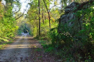
Badger State Trail, Rock wall and bridge

Rock Wall and Bridge on the Badger State Trail

I had originally ridden the southern part of this trail a few years back when a friend and I rode the Jane Addams Trail which runs from Freeport to the Illinois/Wisconsin border and then connects to the Badger State Trail. We rode the JAT from Freeport, Il to Monroe, Wi on that trip so I continued my ride this year heading north from Monroe, Wi.

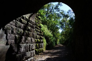
The Badger State Trail (BST) is a nice, scenic, rural Wisconsin trail but the highlight of this trail is definitely the 1/4 Mile Long Tunnel which is located about 4 miles south of Belleville.

Badger State Trail Tunnel Looking Out

Looking out of the southern entrance of the tunnel.

I took quite a few photos, as usual, to document the trail and give you a feel for what it is like, but I probably took more photos of the tunnel since that is the more unique features of this trail.

The only other trail that I have ridden with tunnels like this is the Elroy-Sparta Trail, which has 3 tunnels. The Tunnel on the BST is more like Tunnel #3 on the EST (which is the one that is closest to Sparta) since both of these tunnels are fairly long and you can’t see the exits at either end when you are in the middle of either tunnel.

You will need a light with you to pass through the tunnel (or at least a stick like a blind person would use, but I would recommend a light). I had a bike light with me although I did not have the handlebar clip attached so I had to hold it as I rode.

When I passed through the tunnel there was a young family passing through also and they all had helmet lights on (like coal miners on bikes!). Later on there was a guy that came through the tunnel using the flashlight app on his iPhone. I tried that on my way back but it was not a good as my bike light.

I actually ended up taking more photos from inside the tunnel, looking out, rather than outside the tunnel. This can be a little tricky due to the light (or lack of light) but it can also produce some fairly unique situations and photos.

Of course, I have uploaded a batch of the photos that I took on my ride and have documented the trail and my specific ride on the Badger State Trail.

Check out The Badger State Trail Photos and Ride Report HERE.

I have also included the GPS Map and data from my bike computer on these pages.

McHenry County Prairie Trail Construction and Bridge Out

Just a quick update to let you know about some construction on the southern end of the McHenry County Prairie Trail, just north of where it connects to the Fox River Trail (in Algonquin).

This update and the photos are from my friend and fellow cyclist Dale Kiffel (I have not been on the Fox River Trail or Prairie Trail myself yet this year).

New Bridge on Prairie Trail

New bridge being built 3/4 mile north of Algonquin Road.

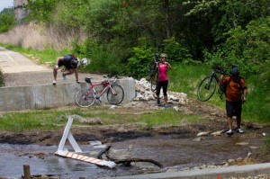
The main obstacles on this trail right now are where the trail crosses route 31 in Algonquin (there is some major construction going on there) and where they are building a new bridge about 3/4 of a mile north of the Algonquin Road overpass.

The first photo on this page is where they are building the new bridge. The trail is closed but, as you see by the determined cyclists in the photo, it is possible to get to the other side if you are determined.

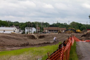
The second photo in this post is the construction at Route 31 in Algonquin. It looks like it could be difficult to get through here too but there is also a cyclist getting through this section too.

Prairie Trail Construction

McHenry County Prairie Trail construction at Route 31 in Algonquin.

So if you are planning a trip on the northern end of the Fox River Trail and connecting to the Prairie Trail to continue north (or planning a ride the other way on the trail) be aware that you may not be able to get through or there may be some tricky obstacles or detours that you will need to take.


Flooding on West Side of Paul Douglas Trail

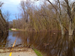
I was just out to the bike path that goes around Paul Douglas Forest Preserve (in Hoffman Estates (on Monday 4/29)) and discovered that the trail is flooded once again on the west side of the trail (the part that runs parallel to Huntington/Freeman Road).

Pauld Douglas Bike Trail Flooding

The flooding on the west side of the Paul Douglas Bike Trail.

This part of the trail has flooded quite a few times and I have even written about it before here. It makes sense that this part of the trail would be flooded with all the other flooding that we have had in the area this year.

It actually used to flood a little worse in the past than this time (although it may have been worse before I made it out to the trail this time). They actually dug up this part of the trail shortly after it was built, added a few large drainage pipes under the trail and re paved it again to help with the flooding but it was not completely successful (although it did help a little bit).

The photo that I have included here is from my iPhone and shows how the trail looks as you are looking down the trail from south of the flooded part (looking north). There were even a few geese swimming around on the trail when I was there! You can see one of them in the photo in the distance on the right.

You can get around this part of the trail fairly easily by crossing over the Huntington/Freeman Road which it is right next to the trail at this point and it is just a very short detour. As I was taking the photo here I saw one rider go down to the flood and it looked like he was going to ride through it but he chickened out and ended up going around.

You can see the yellow line (from the trail) through the water and I believe that it is only about 4 inches deep so if you are adventurous (and don’t mind getting your feet wet) you can ride through it too. I have done this in the past (although I was on foot in this case).

That’s it for now… I’ll have more trail updates when I am able to ride more.

Deer Grove Orange Trail Conditions, about-bicycles updates…

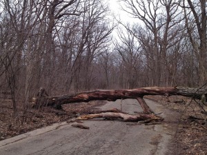
I was just out on the Orange Trail in Deer Grove yesterday and wanted to post an update on the condition of the trail since there were some downed trees. The Orange Trail is the old abandoned forest preserve road that they closed to automotive traffic. I actually remember many years ago when you could drive on what they now call a trail but that was quite a while ago. You get on this trail from the entrance off Dundee Road just east of Northwest Highway.

Fallen Tree in Deer Grove

The first tree over the Orange Trail

The Orange Trail is not very long (a little over a mile one way) but it is one of my favorite trails in Deer Grove and can be used to get from one trail (or road) to another. I walked the trail yesterday since I have been unable to ride so far this season due to an injury (my physical terrorist  🙂 has now given me permission to start riding short distances again so I should be back in the saddle again for this season soon).
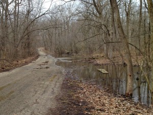
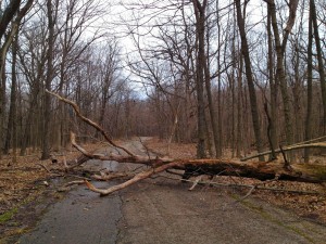
Anyway, what I discovered yesterday is that there are 2 huge trees that have fallen on to the trail and I don’t believe that you can ride around them on a bike without stopping and either walking around or under them. The trail was also under water on one side in one of the ravines but you could still get by easily on the other side. The trees that were on the trail look like they fell over due to all the rain and flooding and the wet ground since you could see how their roots came out of the ground.

Flooding on Orange Trail in Deer Grove

The high water over some of the trail

They maintain the trails in Deer Grove pretty well (it’s a Cook County forest preserve) so I imagine that they will get out there and get these trees off the trail eventually but I don’t know how long it’s going to take them to get to it. So you just need to know that if you ride on this trail there are some obstructions that you’ll need to get around.

We have had a lot of flooding in the Chicago area this week so I was worried about flooding on the trails. This trail in Deer Grove was not bad but I know there has been flooding along the Fox River and the Des Plaines River so I’m sure parts of those bike trails are flooded too.

More fallen trees on Orange Trail in Deer Grove

The second fallen tree on the Orange Trail

The river does not have to be that high to flood the underpasses on the Des Plaines River Trail. I’ve seen that happen before as in the photos on this page.

About-Bicycles Updates

Sorry about the long time between posts here, I am usually much more active with this blog. Although we have not had the greatest riding weather recently, we have had a few good riding days but as I mentioned above I have had an injury that has prevented me from riding so far this season.

The main reason though that I have not been on schedule with my blog updates and have fallen a little behind on a few other updates to the site is because I am still trying to recover from the last Google Bashings that this site has had.

I have mentioned this before in some of my other posts but if you missed it we lost a large amount of traffic to this site with the recent Panda and Penguin updates from Google. We still rank higher in the Search Engine Results for Bing and in a lot of cases I have found the Bing results to be more relevant.

It seems to me that Google is ranking the popular super-sites on the internet higher on most search terms regardless of how relevant the specific results are. For example, you always see Wikipedia, You Tube, Amazon, TrailLink (for bike trails), Flickr (for photos), etc. even when they don’t match the specific term that you are searching for. Plus often you get multiple (like 10 or more) search results for the same website (let’s have some variety!).

OK, I could ramble on a lot more about Google’s degraded search results but I need to get back to the topic that I was originally discussing.

One of the penalties that you get with the Google Panda update has to do with “Thin Content” and I think there is a possibility that my bike trail photo pages may have inadvertently caused me problems in this area.

The bike trail photo pages on this site were designed simply to showcase the bike trail photos with very brief captions on most of the photos. Well, I discovered that we have about 250 photo pages on this site and most have very little content because they were designed that way.

No one really knows what the exact Google algorithm is for their search results (except for the people at Google) but I have read that pages with less than 300 words as content could get penalized by Google and if there are a large number of these on your site it could cause problems. Well I have a very large number of photo pages with very little content other than very brief captions.

So anyway, one of the main things that I have been working on is increasing the content on these pages so I am backtracking and adding much more commentary to all the bike trail photo pages and this has been slow and time consuming.

In some cases the additional content just looks like “fluff” but I have discovered that adding more verbiage does actually add more depth the the photos and articles and can be helpful too in many situations.

Well, I knew that this topic was going to be hard to explain and I’m afraid that this part of the post got longer than I intended.

For those of you who made it this far and were interested, I hope that this explains why there hasn’t been many blog posts recently and that I am still working hard to recover from the latest Google bashings so I can continue with more relevant and quality updates to this website.